Acoustic noise maps – exchange and integration of data within various database systems
INTRODUCTION
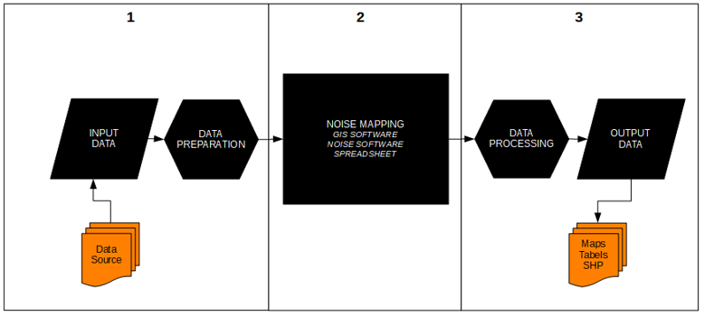
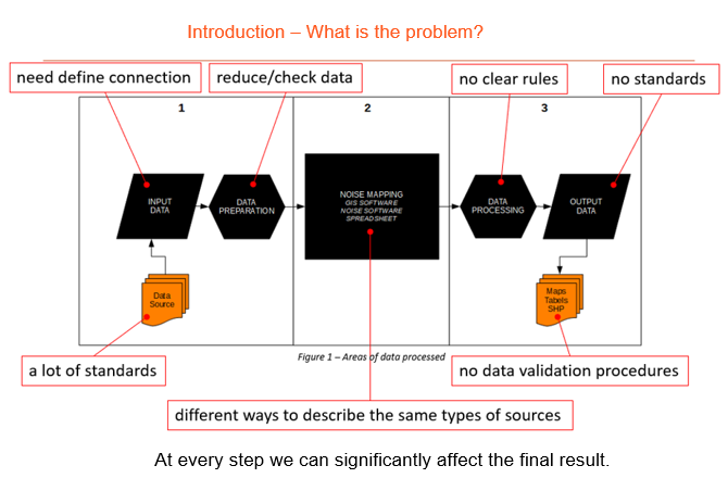
In accordance with the European Union Directive 2002/49 / EC, each member country is obliged to develop acoustic maps. By 2019, the calculation methods are set out in Annex II to Directive 2002/49 / EC. From 2019, the new CNOSSOS-EU calculation method described in Directive 2015/996 applies. A detailed description of individual methodologies and methods of creating acoustic maps can be studied in the CIRCABC platform managed by the EU. All data developed as part of acoustic mapping should be reported in accordance with the defined mechanism [4]. All of the above issues have been codified. However, there are no clear standards for obtaining, processing and exporting data. One of the few good examples are the guidelines developed at the beginning of the process of developing acoustic maps. When developing an acoustic map, there are three data areas to be processed, as shown in Figure 1.
Figure 1.
The following chapters describe data sources, problems and needs related to their processing, new possibilities of data acquisition and processing, and directions for further work.
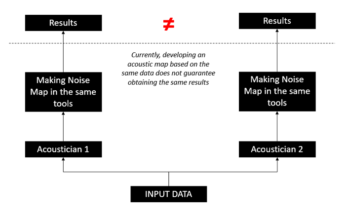
For example.
If we give the same information to the acousticians. And each of them will make an acoustic map with the same tools.
The end result is very likely to be different.
DATA SOURCE
To prepare noise map we need to process a lot of data from different sources of origin. Most data sources are not adapted to the needs of acoustic mapping and require several stages of processing. This processing is not standardized and each map maker does it according to his experience and general knowledge. In addition, each noise calculation program has different ways of processing and storing data, which further complicates the situation.
Exchange / Integration with acoustic data
When creating acoustic maps, it is necessary to use many data sources such as Numeric Model of Terrain (NMT), Building Data Base (BDT), Environmental Data Base (cover, bridge, etc.) and others. For these data it is necessary to apply a layer of acoustic data such as traffic parameters and type of pavement for roads/rails, sound power level for industrial source, noise barriers, etc. The sources of these data may vary, including those based on open licenses(OpenStreetMap, Inspire), paid government data (NMT, BDT, etc.). Each of the above data can be presented in several generally used data formats. All data was integrating in the noise map calculation programs. This approach blurs the transparency of data.
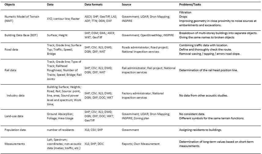
A summary of the input data, their formats and sources are presented in Table 1.
Table 1 – Input data, their formats and source
Example (ICA 2019 presentation fragments)

Numeric Model of Terrain (NMT)
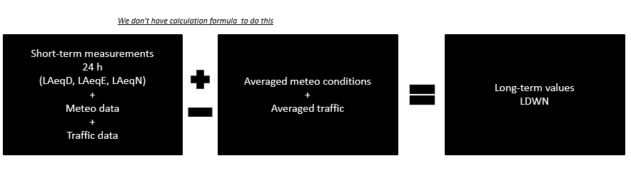
Measurements
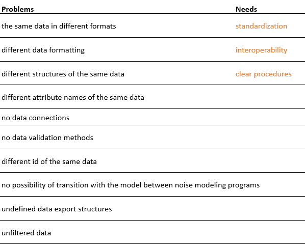
Problems and needs
The multitude of data, their sources and formats as well as methods and processing tools lead to many problems. The main need is to develop clear procedures, standardize data and ensure their interoperability. The goal is to develop methods that allow the largest possible automation of data processing and validation. Table 2 summarizes the most important problems and needs.
Table 2 – Problems and needs
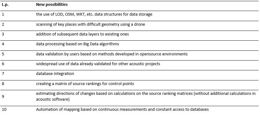
NEW POSSIBILITIES
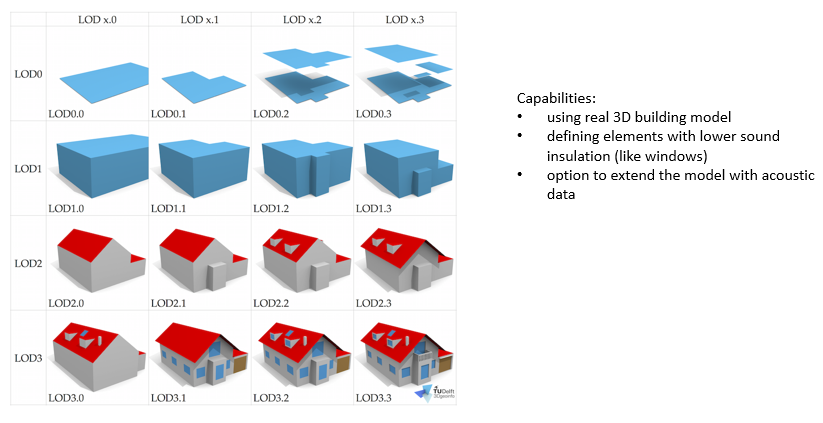
Looking at all processes related to the development of acoustic maps and other areas of management of a large number of spatial data, methods should be developed that will interact with existing ones. It seems natural to use good experiences, methods, tools and data structures developed in OpenStreetMap, CityGML and OGC type projects, which could be easily supplemented with acoustic data and used in the development of acoustic maps.
Another place of new possibilities is the common publication and the use of data developed on acoustic maps in other acoustic projects. Currently only final results are available in the form of maps and tables. However, there is no access to data accepted for calculations and processed for acoustic needs. This often results in the re-generation of the same data with other acoustic assessments of the same noise sources and prevents data validation in the process of their self-improvement (eg improvement of geometry at each next noise counting process).
Dissemination of drones as a tool for collecting spatial data can significantly accelerate the process of creating maps and refreshing geometry data.
When looking at the number of data processed, one should also consider using Big Data processing algorithms that would allow to automate data validation processes.
Another field for creating new tools is creating a matrix of source rankings, which can enable quick estimation of the direction of changes without the need to perform repeated time-consuming calculations.
The last field of new opportunities is the attempt to automate the mapping process based on continuous measurements and constant access to databases.
Table 3. summarizes the most important new possibilities related to the development of acoustic maps.
Table 3.
INTEROPERABILITY
Definition: “Interoperability is a characteristic of a product or system, whose interfaces are completely understood, to work with other products or systems, at present or in the future, in either implementation or access, without any restrictions.”
When creating the data structure associated with the acoustic map, it is necessary to maintain the data interoperability.
Currently, we all process data without a well-developed homogeneous structure and processing methods.
At the moment, even the usual transfer of data from one program to the other noise calculation program becomes a problem.
A good starting point would be the transition to open data formats and open environments for their processing. An example of this is the recent work of French researchers who have successfully attempted to create an acoustic map in an open source environment.
ACTION PLAN
Based on the above review, the following steps are proposed:
- Step 1: overview of used data,
- Step 2: review of data structures,
- Step 3: definition of needs (what data are necessary, in what format, in what detail, etc.),
- Step 4: review of open data structures (OSM, CITYGML, WKT, etc.),
- Step 5: creation of basic data structures,
- Step 6: standardization of data processing,
- Step 7: creation of data validation methods,
- Step 8: development of final standards, guidelines and methods of data processing.
The development of uniform standards, guidelines and methods will allow for a correct assessment of the scale of the noise problem and will enable a reliable assessment of the results between individual countries. Currently, the work is focused on the creation of new assessment methods, forgetting that the result of acoustic mapping is strictly dependent on the input data and methods of their processing. Without standardization in this area, each map will be the original project of its creator and it will not be possible to reliably compare results in the next edition of the maps.